PLEASE NOTE: As of January 1, 2023, the technology connecting CBL to the Southern Maine Transit Tracker (SMTT) has reached end of life. As a result, the SMTT will no longer show CBL ferries. Updates will be provided as a new system is implemented. We apologize for any inconvenience.
About the SMTT
The Southern Maine Transit Tracker (SMTT) is a ride tracking system released by Casco Bay Lines (CBL) in partnership with Metro and South Portland Bus Service. Computer and GPS devices installed onboard all CBL ferries provide real-time and predicted arrival information to riders. The real-time Map is SMTT’s interactive web map that riders can use to track CBL vessels sailing on Casco Bay, and view estimated time of arrival (ETA) and “next stop” information for all vessels on a regularly scheduled trip. Although this map can be accessed on a mobile phone using a 3rd party mobile app it is more useful when viewed on larger devices such as tablets, laptops and desktop computers.
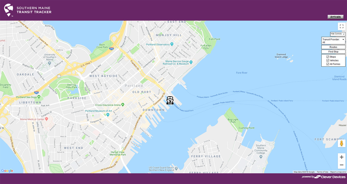
Below is photo of the map. Click on it to access the SMTT Interactive Map and other information available on the SMTT website.
How to Use the SMTT Real-time Map
The SMTT real-time map utilizes a number of interactive elements including menus, buttons and pop-up windows. Begin by locating the legend in the top right corner of the map. If this legend is not visible click the “Show Controls” button (also in the top right corner of the map) to expand the legend.
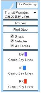
Transit Provider: This drop-down menu allows you to select Casco Bay Lines, Metro Bus or South Portland Bus Service (or all) for viewing on the map.
Routes: Clicking this button in the legend causes a route selection box to pop up in the top left corner of the map allowing you to select the route(s) you want to view for the transit provider(s) you have selected. All routes that have been selected will appear at the bottom of the legend with the route abbreviation and color code.
Find Stop: Clicking this button in the legend causes a selection box to pop up in the top left corner allowing you to select the stop ID(s) for your selected stops on the map. Entering an ID will highlight the selected stop on the map. If routes that do not service your stop are displayed on the map while using this function, you will get a message letting you know the stop is not serviced by that route. Turn off that route and repeat the search. An alternate way to find the stop is to select the routes listed in the Find Stop pop-up and follow the steps.
Stops, Vehicles, All Ferries: Checking any of these boxes will turn on or off these map features. The default is “All Ferries” which will display all ferries at all times otherwise all those ferries logged into the system will be displayed.
Reading the Route Lines, Stops and Colors
The Casco Bay Lines schedule is organized and depicted on the real-time map by three separate routes: Down Bay Service (DB), Inner Bay Service (IB) and Peaks Island Service (PK). The route lines drawn on the map depict the most common path of travel. There are times when a vessel must sail an alternate path. In these instances, if the distance of the alternate path is too far from the programmed path, the vessel will be shown as off-route (OR) and predicted arrival times will not be available.
![]() The Peaks Island Service (PK) Route
The Peaks Island Service (PK) Route
The Peaks Island service route begins at the CBL terminal in Portland and travels to Peaks Island (stop ID is also PK). This route does not stop at any other Casco Bay Island. A vessel on this route is depicted on the map with a red vessel icon and route line.
![]() The Inner Bay Service (IB) Route
The Inner Bay Service (IB) Route
The Inner Bay service route begins at the CBL terminal in Portland and stops at one or more of the following stops (listed with their corresponding stop IDs): Little Diamond (LD), Great Diamond (GD), Diamond Cove (DC) and Long (LO). A vessel on this route is shown on the map with a blue vessel icon and route line.
![]() The Down Bay Service (DB) Route
The Down Bay Service (DB) Route
The Down Bay service route begins at the CBL terminal in Portland and stops at Chebeague (CH) and Cliff (CF) islands. Depending on the schedule, this route may also include stops at one or more of the Inner Bay service route stops. A vessel on this route is shown on the map with a purple vessel icon and route line.
Scheduled departures times from each stop along all routes vary based on the published seasonal schedule.
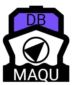
Vessel Icons
When zoomed-in on the map, the abbreviated route and vessel names are visible on the vessel icons. The route abbreviation (DB, IB or PK) will appear on top of the icon if a vessel is on a trip. In some cases, if a vessel is traveling on a specialty cruise or chartered tour, or may not be transmitting information to the map, the letter U (Unknown Route) will be visible and the vessel icon will be white. At times it is necessary for a vessel to sail off the programmed route by a distance too great for the system to process. When this happens, a vessel will temporarily be displayed with a white icon and the letter OR (Off-Route) in place of the route name abbreviation. To ensure visibility of both off route (OR) and unknown route (U) vessels, be sure that the “All Ferries” box is checked in the legend.
The abbreviated vessel name is visible across the bottom of the vessel icon when zoomed-in. Vessel names have the following abbreviations:
- AUCO – Aucosisco III
- BAYM – Bay Mist
- MACH – Machigonne II
- MAQU – Maquoit II
- WABI – Wabanaki
The arrows in the center of the icon indicate direction of travel. An example of a vessel icon is shown below.
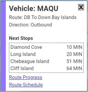
Utilizing the Estimated Time of Arrival (ETA) Window
Ferries on regularly scheduled service are linked to a database enabling the SMTT system to estimate arrival times at each stop along the route. ETA information for a vessel on a trip within a 30-minute look-up window can be found using the real-time map on any web-enabled device. Additionally, users can text “SMTT (stop ID)” to 41411 for ETA information for a stop.
On the real-time map, ETA windows can be accessed by either hovering over or clicking on a vessel or hovering over or clicking on the red stop symbol. The predictions are based on departure time, travel speed and distance to the stop and update as the trip progresses. No matter what predicted arrival time is displayed, a good rule of thumb is that passengers should always plan to arrive 5 minutes prior to the scheduled departure times.
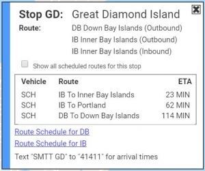
Examples of the ETA window are shown below.
Example Vessel ETA Window
Example Stop ETA Window
ETA Glossary
Terms used in the ETA window include:
ETA – Estimated time of arrival.
SCH – Scheduled time. This is displayed if the vessel is not yet on the trip or the arrival time is greater than 90 minutes away.
Approaching – This will be displayed when the vessel is estimated to be 3 minutes or less away from the stop.
Vehicle – Vessel name abbreviations.
Route – Route name abbreviations.
Direction (Outbound) – The direction of travel leaving the CBL terminal in Portland and traveling to the islands.
Direction (Inbound) – The direction of travel heading back to the CBL terminal in Portland from the islands.
Stop ID – Stop name abbreviations.
Next Stops – The stops that are part of the route pattern listed in order.
For more information about SMTT, the SMTT real-time map and other tools, visit https://smttracker.com. Should you encounter any problems and need assistance, please contact moc.r1714170096ekcar1714170096ttms@1714170096ofni1714170096.