At Casco Bay Lines we have a long and storied history, but we’re also always looking ahead to the future. This month, we’re excited to unveil our new tech offering, the CBL Live Map.
If you’re a regular commuter, you may have already heard wind of this tool. We’ve received a lot of positive feedback since we quietly launched it this fall. One commuter reached out via our online feedback form this past week to tell us: “Your new live map is absolutely awesome and works with ease. Good job.”
What is this map—and where can I find it?
The CBL Live Map allows riders to see in real-time which ferries are traveling through Casco Bay at any given moment. It is updated every 15-30 seconds, and gives you an instant, interactive way to plan your schedule and see important service updates. And importantly, it’s fun and easy to use.
There are two ways to view the CBL Live Map. The first way—which is helpful if you’re a beginner—is to head to the CBL website homepage and click on the “Live Map” button on the top navigation. It’ll bring you to this webpage where you can watch a short video about the tool and follow instructions on how to save the map to your phone’s home screen in 4 simple steps (either Apple or Android). You can also visit the map directly here: https://livemap.cascobaylines.com/.
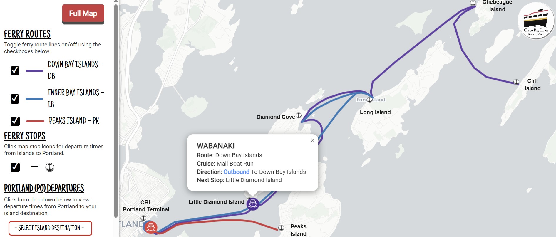
The map allows you to do three key things:
- Plan your trip: Select your island from the dropdown to see departure times and route names. Then click that island’s stop icon on the map to view return times. To make things personalized, you can select your route and uncheck other routes: Down Bay Islands, Inner Bay Islands or Peaks Island.
- Track ferries: Follow ferries in real time and tap icons to see ferry details, route or cruise name, direction of travel, and next stop. The live positions update every 15–30 seconds.
- Travel with ease: The map works in your mobile browser—no app download is required. You can also add it to your phone’s home screen for one-tap access whenever you’re planning a trip or heading to the terminal. If there are ever any important service updates—you’ll see them across the top of the map.
How did this technology come about?
The CBL Live Map was funded with Federal Transit Administration Section 5307 Urbanized Area Formula funds for the Portland region and suballocated to Casco Bay Lines for Intelligent Transportation Systems upgrades (with a 20% local match).
The project began in earnest in July 2024 when CBL partnered with the Maine-based Pine Tree Project Management Pros, LLC, to manage the process. CBL procured two cloud platforms, Remix by Via—which formats CBL’s sailing schedules into the General Transit Feed Specification (GTFS)—and Swiftly, Inc., which converts onboard GPS data into GTFS-Realtime.
Together, these two systems power the CBL Live Map so riders can see current vessel locations, plan trips from the Portland terminal, quickly view island departure times back to Portland, and receive service alerts issued by CBL staff. In addition to driving the Live Map, the same data feeds CBL gate displays, Google Maps, Apple Maps, and the Transit app.
With this modernized back end, CBL can now greatly reduce routine calls to the ticket office regarding vessel location, scheduled departures, and service advisories. Because GTFS is an open standard, we’re also able to further build on these platforms to add new tools and reports that improve our overall day-to-day operations and the rider experience.
We’re excited to offer this interactive map to the community. But we want to hear from you! Do you have any feedback? Head to our feedback form and tell us what you think.